
It’s going to be a blustery day across Chatham-Kent.
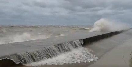
A special weather statement from Environment Canada is calling for high winds this afternoon into tonight, with westerly gusts reaching 70 to 80 kilometres an hour.
The strongest winds are expected near the eastern shores of the Great Lakes, with the potential for gusts up to 90 km/hr.
Officials from the Lower Thames Valley Conservation Authority say there’s a risk of flooding along Erie Shore Drive and the potential for shoreline damage and erosion all along the Lake Erie shoreline, including the high bluff areas.
“The degree of flooding would depend on the wind speed, direction and duration,” a statement reads. “With temperatures near the freezing mark overnight Wednesday into Thursday morning, there is also the potential for icy conditions should wave spray or any flooding occur. Residents should monitor local conditions and be prepared.”
The wind could toss loose objects and cause tree branches to break. Officials say isolated power outages are also possible.