
The Lower Thames Valley Conservation Authority is warning of the potential for more flooding along the shorelines of Lake Erie and Lake St Clair.
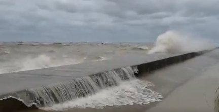
Officials say although current levels are lower than they were this time last year or even the year before, the lakes are still well above average and sustained winds could cause more flooding, erosion, and shoreline damage.
Average daily water levels on Lake Erie at the beginning of April were around 174.62 metres. This is down about 52 cm from last year’s peak daily average water level record set at the end of May. It is also 44 cm lower than it was on April 1st, 2020. The all-time record high monthly average for April was 175.05 m, set last year. Water levels on April 1st were still 38 cm above what would be considered normal for the month of April. Water levels have started their seasonal rise and water level forecasts are predicting water levels to climb around 10 cm over then next month.
Average daily water levels on Lake St. Clair at the beginning of April were around 175.58 metres. This is down about 50 cm from last year’s peak daily average water level record set during the third week of May. It is also 38 cm lower than it was on April 1st, 2020. The all-time record high monthly average for April was 175.91, set last year. Water levels on April 1st were 52 cm above what would be considered normal for the month of April. Water levels have started their seasonal rise and water level forecasts are predicting water levels to climb around 8 cm over then next month.
In the most vulnerable areas, such as Erie Shore Drive in Chatham-Kent, wave spray related flooding can begin at sustained wind speeds as low as 30 km/hr, while other less vulnerable areas may need wind speeds closer to 45 km/hr. Gale force winds of 60 km/hr could be expected to cause significant flooding and shoreline damage to any low lying shoreline area. The area’s most frequently impacted communities and the relevant wind direction include: Lighthouse Cove when winds are out of a north through west direction; Erie Shore Drive when winds are out of the south (SW through SE); the bay side of Erieau when winds are out of a north through east direction; Shrewsbury when winds are out of the east (NNE through ESE); and Rose Beach Line when winds are out of a south through northeast direction. The LTVCA says other shoreline areas are also susceptible.