
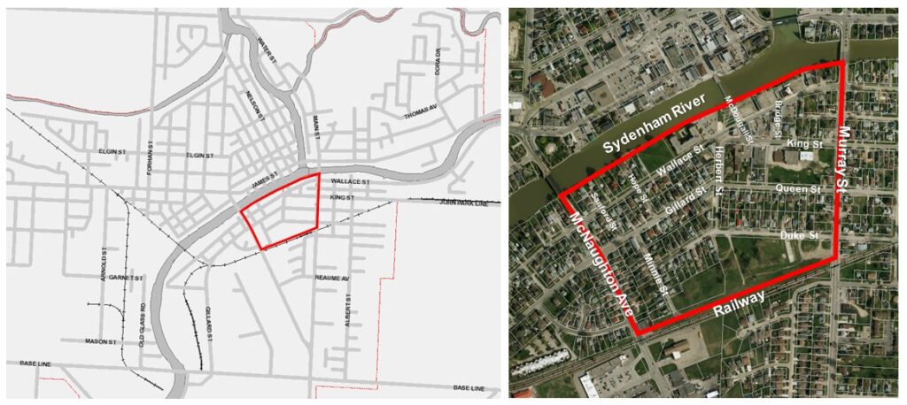
The southern shore of the Sydenham River in Wallaceburg could soon be graced by a new park, residential space, and more.
At its meeting Monday night, Chatham-Kent Council approved and adopted the second draft of the Wallaceburg South Side Secondary Plan, which will create a vision for the area just south of the Sydenham River across from Wallaceburg’s downtown core.
Officials say the plan will help to establish future land use policies for guiding future land redevelopment in the area, and will feature a new waterfront public space along the river, which connects to the walking bridge and a boardwalk along the river.
The plan also includes a public-use building, a pedestrianized street, and 200-250 new residential units , which would be a mix of developments, including affordable and senior housing.
There were two deputations at Monday night’s meeting, each with different visions for the land along the river from Murray Street to the walking bridge.
Wallaceburg businessman Peter Allaer said he had objections with the plan regarding the ratio of the area that is planned to be green space versus the amount of area that can be developed. Allaer owns a number of properties in the area on the south side.
He said there are a number of waterfront parks already in the area, noting Library Park, (Kinette) Park, Civic Park and Crothers Conservation Area. He said 60 percent of the proposed southside plan is planned for green space.
“I think we do have a bit of green space on the river already,” Allaer said.
While he understands the need for a boardwalk along the Sydenham River, Allaer said he objects to having the boardwalk and green space to be so wide along the river, noting he is hoping for a compromise regarding green space and area for development.
Allaer said the south side is a prime area for development.
“I think if it is done properly, we can bring a lot of people in (the) area to the core. Hopefully when you bring people to the core it helps the whole town,” Allaer said.
Wallaceburg resident Tony Myers had the opposite concerns with the proposed draft plan, noting that potential residential and commercial developments should not be along the river, but should instead go on the south side of Wallace Street. Myers said the area along the river should be reserved for parkland and public use to promote and revitalize tourism.
“This is a prime opportunity to develop a peaceful and tranquil setting that would enhance the southside and the downtown core,” Myers said.
The next steps for the area’s development include amending zoning by-laws in the project area to reflect land use policies, land acquisition process, public space planning/development, identifying external funding opportunities, and feasibility studies.